Thursday, December 6, 2012


Physical geography of Badlands National Park
Badlands National Park has an arid steppe climate and is located in the Southwest part of South Dakota. Some of the most recognizable geographic landforms in Badlands National Park are Buttes, Pinnacles, and Spires. The main geographical factor that has helped shape the park into its current state is erosion. Erosion is the transfer of weathered material from one location to another and can happen at many different rates. The estimated rate of erosion in Badlands National Park is about one inch per year. There are several different ways for erosion to shape and change an areas physical geography. One way is by physical weathering, this process is the disintegration of rocks or minerals by a physical or mechanical process.  Another process that helps erosion is salt weathering; this occurs when salt crystals get wet and expands, often forming cavernous erosion in rocks and minerals. Another cause of erosion is a process of weathering involving sand and wind; however this is usually not as damaging as other forms of weathering. The main process responsible in the erosion of Badlands National Park is physical weathering, with water being the strongest force.
This image epitomizes the physical geography of Badlands National Park, this area has been eroded down and not built up. Image credit: http://www.tssphoto.com/index.php?p=788

Possible physical landscape of Badlands National Park in 1000 years

I hypothesize that in 1000 years the landscape of Badlands National Park will look similar to today’s landscape but with more extreme erosion and a drier climate. One way to support this hypothesis is that currently Badlands is eroding at one inch per year and will continue to erode at this rate. Also because the Park is in a rain shadow from the Rocky Mountains the climate will remain dry.
One of the most recognizable land forms in the park is “the wall”, with the current erosion rate this area might be unrecognizable in the future. Image Credit: http://travel.nationalgeographic.com/travel/national-parks/badlands-national-park/

Possible physical landscape of Badlands National Park in 10,000 years

At the rate that Badlands National Park is eroding any current landscape features would be unrecognizable in 10,000 years. This is because over 800 feet would be eroded in 10,000 years at the current rate, this does not bring into account possible catastrophic events. So it is possible that another major volcanic eruption could take place in the Yellowstone area and ash from that could add to the Park.
This is the possible area of ash fall if another massive volcanic eruption happened in the Yellowstone area. Image credit: http://viewzone2.com/yellowstonex.html

Possible physical landscape of Badlands National Park in 1,000,000 years

It is hard to hypothesize the possible state that the landscape of Badlands National Park could be at in one million years. But using the uniformitarianism concept that what has happened in the past will happen again in the future. I believe that it is possible of a low lying sea or ocean in the area of Badlands National Park. This is because there is fossil evidence that there was a low lying sea during the Cretaceous period covering parts of South Dakota and much of mid-America.  
This image depicts how the US looked during the Cretaceous period and could possibly look if another low lying ocean covered middle America in the distant future. Image credit:
Summarization of current and future landscapes of Badlands National Park

Overall I believe Badlands National Park will continue to erode at the current rate and will remain an arid climate. The only exceptions to this are catastrophic events that are hard to predict and could change the geography of the park.


This image is a panoramic view of the Badlands and is a good depiction of the eroded landscape that makes up the majority of the physical geography there. Image credit: http://parks.mapquest.com/national-parks/badlands-national-park/

Tuesday, November 13, 2012

Weather In Badlands National Park

The weather in Badlands National Park varies greatly throughout the year, from snow in the winter months to strong thunderstorms in the summer months. There are also significant variances in temperature and amounts of precipitation throughout the year in Badlands National Park.

Badlands National Park Weather Averages
 
JanFebMarAprMayJunJulAugSepOctNovDec
Avg. High34°38°45°57°68°77°86°85°74°62°46°35°
Avg. Low10°15°22°32°42°51°58°56°45°34°22°12°
Daily Avg22°27°34°45°55°65°72°71°60°48°35°24°
Avg. Precip.0.4 in0.5 in1.0 in1.9 in2.7 in3.1 in2.0 in1.7 in1.3 in1.1 in0.6 in0.5 in


The chart above depicts the average high and low temperatures throughout the year, notice that July is the hottest month on average and January is the coldest month on average. The chart also shows average precipitation throughout the year, with the spring and summer months being the wettest and fall and winter months being dryer.


Thunderstorms are a common occurrence during the spring and summer months in Badlands National Park. Thunderstorms have three basic stages; the first being the cumulus stage, the second being the mature stage, and the final being the dissipating stage. During all three stages there is the possibility of lightning developing and visitors to the park should be aware of this danger at all time.


There are several types of lightning, this photo shows two different types of lightning. The bolt of lightning on the left depicts forked lightning and the bolt on the right depicts ribbon lightning. Lightning is caused by buildup of static electricity in a cloud that is eventually discharged being attracted to its opposite ion (positive to negative and vice versa).


In addition to producing lightning, thunderstorms can also produce tornadoes, which are the most dangerous atmospheric phenomenon on earth.


This picture shows a rare tornado in Badlands National Park, which occurred June 6, 2007. Because tornadoes are so dangerous their mechanics are still largely unknown, but it is believed that they form from air being sucked up from a strong jet stream above the thunderstorm.


Thursday, October 11, 2012

The main geographical factor on how the Badlands in South Dakota look today is erosion. Because the Badlands are made up largely of soft sediments and volcanic ash it is highly susceptible to erosion. Although there appear to be mountains in the Badlands these areas have not been lifted but are the harder sediments eroding slower than the areas around them. It’s not known exactly how fast the Badlands are eroding but the consensus seems to be about one inch every year.
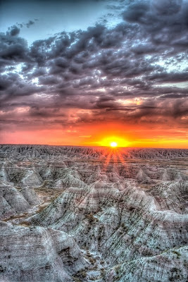
A spectacular sunrise in Badlands National Park.

Because the Badlands have eroded so much there are steep slopes and lots of loose earth, both of which are conducive to landslides. One area in which these landslides have been fairly large and have affected people is along the Norbeck Pass which is in the Eastern part of the National Park. Here there have been several landslides which have blocked the road and caused costly repairs to the road.
Norbeck Pass where landslides have occurred and blocked the road.
 
Badlands National Park is a very dry place getting only about sixteen inches of precipitation a year, which is very similar to that of Denver’s annual precipitation. But the majority of the precipitation that falls in the Badlands is in the form of rain, which is more damaging than snow and results in many gullies and rills. The landscape of the Badlands is riddled with these water channels formed by overland flow of water and they contribute to the erosion that is happening there.
Gullies eroded into ridges in Badlands National Park.

Much of the soil found in the Badlands National Park is Paleosols, which is ancient soil usually buried beneath layers of rock or more recent soil horizons. There is a large amount of fossil evidence and organic matter in this soil, which is from the vast amounts of living organisms that used to live in this region when it had a semi-tropical climate, around fifty million years ago. The reason that Paleosols is the common soil found is that the rocks and new soil horizons have eroded away over time.
Image of soil horizons found in Badlands National Park.
Image credit: http://picasaweb.google.com/lh/photo/D40lTy48oYh8r04fwtvKfg

Thursday, September 20, 2012

Looking at the Badlands in South Dakota it is hard to imagine that it, like much of the middle of the United States, was once covered in a shallow ocean. As plants and creatures died they sank to the sea floor. Over time these layers were compressed and formed Strata, which is layers of sedimentary rocks. One of these layers of sedimentary rocks found in the Badlands is Pierre Shale. This layer is distinctly darker than much of the other layers found here.
As time passed and the ocean gave way to land, trees and other forms of vegetation grew and died. As they died they decomposed forming areas of peat. After time the peat was covered by sediments and eventually through pressure was transformed into Lignite Coal. Lignite Coal is referred to as the brown coal and is considered the lowest rank of coal. This is largely because of its high moisture content and low energy density. It is mined and used for energy in the United States but more prevalently in European countries.
There isn't a lot of volcanic activity or evidence in the Badlands area. But there are layers of Bentonite, which is largely made up of compressed volcanic ash. The majority of this volcanic ash likely came from the Yellowstone area and was carried east into South Dakota. Over time rain washed the ash into lakes and rivers where it was concentrated and eventually covered with sediment and compressed over time.
Although there is not a lot of volcanic activity in the Badlands there are similar formations to those of volcanic landforms. One example of this is the clastic dike in the Tertiary strata of the Badlands. A dike formed from by volcanic activity is lava flowing vertically in fractures. A clastic dike is formed similarly but instead of lava sediment fills the vertical fractures.
Sources: http://maps.unomaha.edu/Maher/PRF09site/clasticdikes/clasticdikeintro.html http://www.nps.gov/badl/naturescience/Geologic-Formations.htm# http://en.wikipedia.org/wiki/Lignite http://en.wikipedia.org/wiki/Bentonite

Wednesday, August 29, 2012

Initial Blog-Physical Geography

This blog is posted by Jeremiah Lyday,

      My name is Jeremiah Lyday, I am majoring in Business Management at the Univeristy of Colorado Denver. For my blog I have chosen the Badlands of South Dakota, a national park and place of amazing physical geography. I visited the Badlands as a child and was amazed at its ruggedness and beautiful rock formations. One reason I am drawn to this location is the fact that people have inhabited this region and survived, even though it seems to be desolate and lacking of life. Another reason I want to learn about the Badlands is its proximity to Colorado and how the geography here might be similar.